
With our last post, we identified the overall nature of the Chang’e 3 trajectory, now let’s try to narrow it down a bit to see what the landing approach might look like.
Firstly, we should add to the previous post. You might have noticed in the last posting:
Chang’e 3 LOI Geometry (Click to zoom)
We show here a lunar arrival from the North. That’s not the only available approach. We could also approach from the south and get the same inclination:
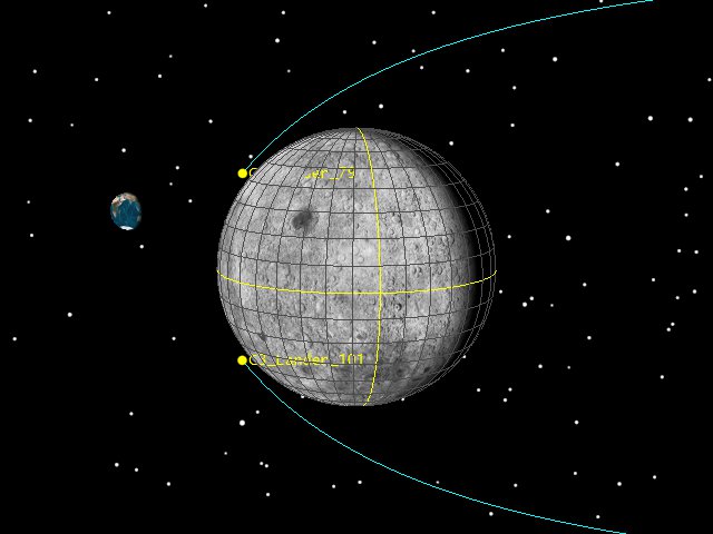
Chang’e 3 North and South LOI approach (click to zoom)
Which gives us two possible approaches to the landing site. Our current information has the spacecraft approaching the site from the south, so we can switch things to accommodate that.
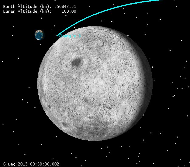
Our Chinese friends announced that they did achieve LOI at 6 Dec 2013 09:53. This time represents the conclusion of a 361 second burn, which places the center of the burn at 9:50. That’s where we can put our impulsive LOI maneuver.
Once there, we’ve been told C-3 circularized in a 100 x 100 km (altitude) orbit.
From there we are told (from Robert Christy @Zarya_info):
1. The periselene was dropped to 15 km on Dec 10 13:20 UTC
2. The periselene will be further dropped to 2 km on the orbit before landing.
3. Landing will take place in Sinus Iridum with coordinates 43.07 deg N Lunar Latitude, 31.05 deg W Lunar Longitude.
5. Landing will take place Dec 14 13:40 UTC with the landing start at 13:26 UTC from periselene
Can we deduce the landing profile, and thus the inclination from this? Perhaps.
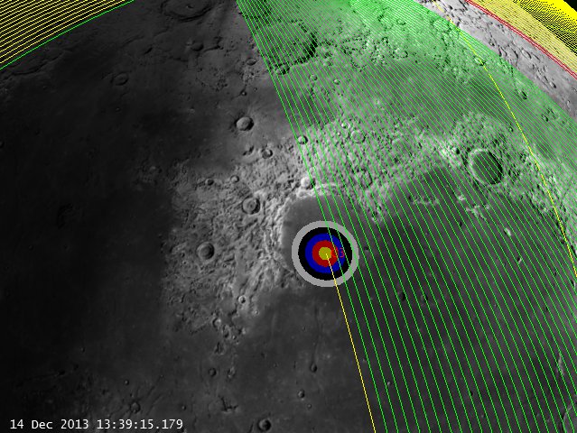
Note that all press so far has referred to this orbit as merely “polar”. While we might assume this means exactly 90 degrees, I don’t think it can be 90 if we stick with the landing site and landing times we list above. See below that if we assume a 90 degree inclination, we can’t get to the appointed landing site at the appointed time (bullseye represents identified landing zone):
90 deg inclination Moon Fixed orbit track (click to zoom)
Note the time in the lower left. Lowering and raising the orbit won’t help, the Moon simply hasn’t rotated under our orbit plane at the landing time. How confident are we of the orbit plane? Pretty confident. The cislunar transfer is relatively fixed. We know the launch time, launch site, perigee location and the transfer time to LOI. We know (roughly) the capture aposelene altitude, so we’re only left with inclination to play with. Could there be a plane change somewhere after LOI? Sure, but this seems like a pretty unlikely fuel cost, especially when we can just get what we want by changing our inclination. Another way of looking at this is to check it out in inertial space:
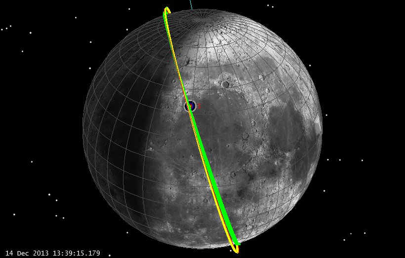
90 deg inclination Moon Inertial orbit track (click to zoom)
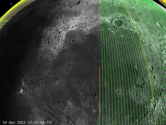
This makes things a bit more clear. Our orbit plane is pretty inertial (note the orbit plane is pretty fixed over a week of time in orbit since LOI). We just have to wait for the Moon to rotate underneath. If we land on the 14th at 13:40, our site just isn’t there yet. However, if we change our inclination to about 105 degrees:
104.7 deg inclination Moon Fixed orbit track (click to zoom)
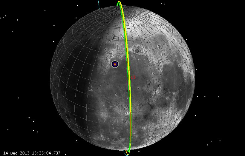
Again with the inertial view:
104.7 deg inclination Moon Inertial orbit track (click to zoom)
We can see that a bit of inclination gives us just what we need, a relatively “polar” orbit, a ground track over the site, and a landing time that’s about right.
Let’s look again at what’s the view of Earth during landing:
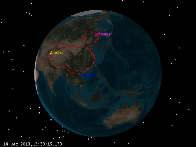
Moon view of Earth at Landing (click to zoom)
Pretty good geometry, all 3 major Chinese ground stations well above the horizon for many hours.
So what are the sources of errors here? Many. We certainly don’t match the AOS and LOS times published. Those can easily be explained by the fact that we don’t know the actual parking orbit dimensions. We’ve been assuming 100 x 100 km circular (and we’ve played with that a bit to make things be timed right) but we’ve got 50+ revs in orbit for errors to build up, and we this assumes a perfect insertion at 100 km periselene, and a perfect insertion. We also don’t know precisely what altitudes were reached with our periselene lowering maneuvers, nor where the first periselene lowering maneuver was targeted (15 km at first periselene after the burn, or 15 km 20 revs later?) So we’ve got a lot of slop. Still, let’s assume that our landing time and landing site are right, and let’s see where a couple of our US satellites are that we know pretty well.
[Disclaimer: While I (Astrogator_Mike) was the trajectory lead during the cislunar phases of LADEE, I am currently only very very part time on the mission as off-site support during science ops, and right now -at this very minute- I am blogging on my spare time on SEE company computers. The trajectory information I am using for both LADEE and LRO is readily available on the JPL Horizons site and comes from there. Thus, no NASA funds, computers, data or assets of any kind were used in the making of this blog posting and I am doing this in my spare time.]
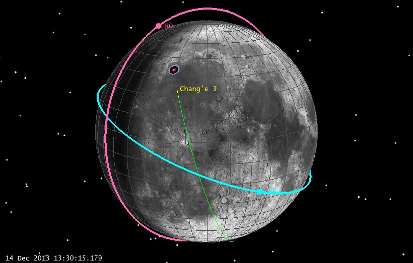
So, where are LRO and LADEE? Based on spice files from the wonderful aforementioned JPL Horizons site, here are where our US orbiting robots are during the Chang’e 3 landing:
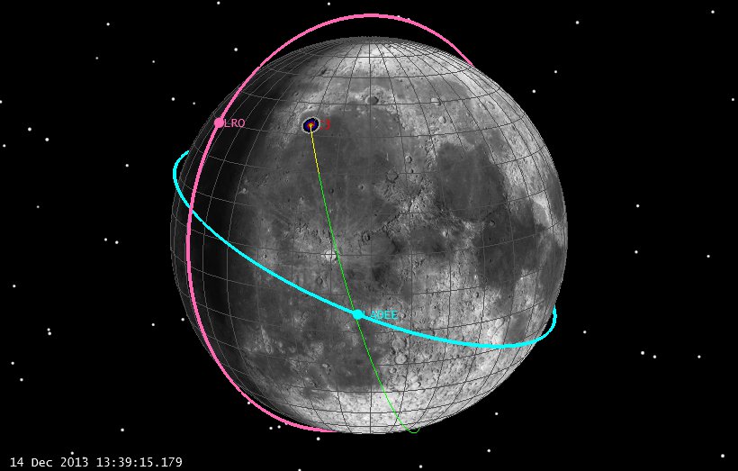
LADEE and LRO geometry at landing (Click to Zoom)
So let’s step through this a bit close to landing and see what our geometry is.

L -10 (click to zoom)

L -8 (click to zoom)
L -6 (click to zoo)
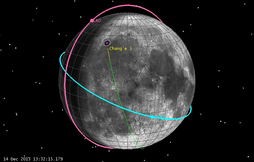
L -4 (click to zoom)

L -2 (click to zoom)
Let’s get a bit closer to the landing site, and see if LRO or LADEE can see the site:
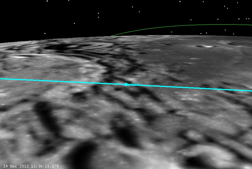
C-3 Landing from LADEE (click to zoom)
Of course LADEE has no camera on board (except the star trackers) but it won’t be able to see anything anyway. LRO, on the other hand, has a decent horizon view of the landing and might be able to see something against the star field. So from LRO we have:
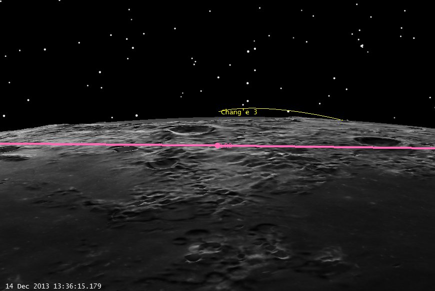
Landing from LRO (click to zoom)
Of course this all assumes that the times we have are right, but if LRO could somehow scan the area over the landing site during the right pass, they might be able to see something.
Regardless, good luck and godspeed to the Chang’e 3 controllers!
-Astrogator_Mike
